|
Zion's
National Park
New!!
Check out our
Form,
Post your favorite locations and see
what others have posted.
Zion's National
Park has three separate areas that
are very different from each other.
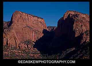 The northwestern part of Zion's National Park is the
Kolob canyon section.
The Kolob area which is higher in
elevation has red rock
mountains with forests of pinions
and junipers. There are two
separate roads to access this
section of the park. The main
access road is the Kolob Canyon road
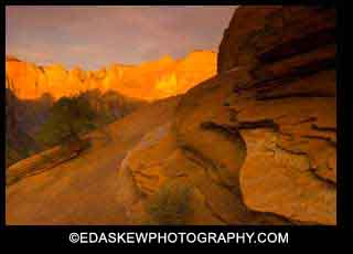
off of I-15 at exit 40 that dead ends into Finger Canyon,
where the photo at the left was
taken. The other access road
is the Kolob Terrace Road outside of Virgin
Utah which connects to highway 14
outside of Cedar City, Utah.. The Kolob
Terrace Road is closed
in the winter. The Kolob
Terrace Road is where you
access the trail
to the Subway Slot Canyon, a nine mile hike on the left fork of
North Creek. You will want to go from the bottom up to the subway. There is a steep cliff at the start so just keep some energy for your return. You will need climbing gear to access the subway from the top. This is a must
canyon to photograph if you are
able. You must obtain a
permit from the visitors center
before hiking there.
Backcountry permits are $5.00.
To make reservations for the subway
call (435) 772-0170. If you miss the deadline for the internet lottery you can go to the BLM office. You get a ball the first day in the lottery and every consecutive
day that you show up, you get an extra ball in the draw so your
chances go up.
The northwestern part of Zion's National Park is the
Kolob canyon section.
The Kolob area which is higher in
elevation has red rock
mountains with forests of pinions
and junipers. There are two
separate roads to access this
section of the park. The main
access road is the Kolob Canyon road
off of I-15 at exit 40 that dead ends into Finger Canyon,
where the photo at the left was
taken. The other access road
is the Kolob Terrace Road outside of Virgin
Utah which connects to highway 14
outside of Cedar City, Utah.. The Kolob
Terrace Road is closed
in the winter. The Kolob
Terrace Road is where you
access the trail
to the Subway Slot Canyon, a nine mile hike on the left fork of
North Creek. You will want to go from the bottom up to the subway. There is a steep cliff at the start so just keep some energy for your return. You will need climbing gear to access the subway from the top. This is a must
canyon to photograph if you are
able. You must obtain a
permit from the visitors center
before hiking there.
Backcountry permits are $5.00.
To make reservations for the subway
call (435) 772-0170. If you miss the deadline for the internet lottery you can go to the BLM office. You get a ball the first day in the lottery and every consecutive
day that you show up, you get an extra ball in the draw so your
chances go up.
The second
area of the park is the deep canyon
section that is accessed
 by
the Zion's Canyon Scenic Drive
outside of Springdale, Utah.
Between April and October there is a
shuttle that provides access to the
canyon. The shuttle has many
stops along the road where you can
get on and off. This area of
Zion's
National Park contains many of the
favorite landscape areas for the
photographer to photograph.
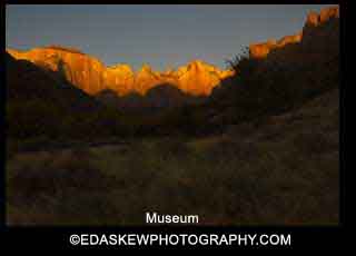
This is a deep canyon with steep
walls of red rock. At
sunrise the favorite photograph
locations are behind the museum, the
end of the Canyon Overlook Trail and
any one of the switch back before
the tunnel on the way to Mount
Carmel. by
the Zion's Canyon Scenic Drive
outside of Springdale, Utah.
Between April and October there is a
shuttle that provides access to the
canyon. The shuttle has many
stops along the road where you can
get on and off. This area of
Zion's
National Park contains many of the
favorite landscape areas for the
photographer to photograph.
This is a deep canyon with steep
walls of red rock. At
sunrise the favorite photograph
locations are behind the museum, the
end of the Canyon Overlook Trail and
any one of the switch back before
the tunnel on the way to Mount
Carmel.
During the day
there are many hikes and wildlife to
photograph along the North Fork of
the Virgin River. The Emerald
Pools trail is a favorite trail with
lots of places to take pictures of
water over rocks and pools with a slow shutter
speed. Wild flowers are
throughout the area in the spring.
The weeping rock trail is an easy
hike to a cliff where water seeps
out of it. This creates
hanging flower baskets that are
beautiful to photograph.
Riverside Walk Trail winds along the
river where you can find interesting
things to photograph all day long.
The river walk trail that starts at
the Temple of Sinawava has many
areas along the river to photograph.
If you want to hike the narrows you
will need a dry bag for your camera
gear.
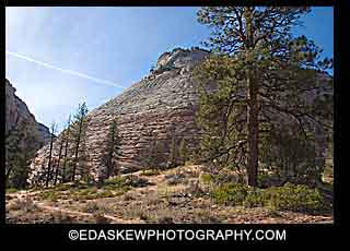
The last area
of the park is east on Highway 9
towards Mount Carmel after you drive
through the tunnel. This area
has white rock with many cracks and
shapes to get you busy
photographing. The famous area
is Checker Board Mesa.
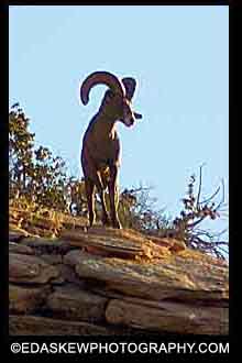 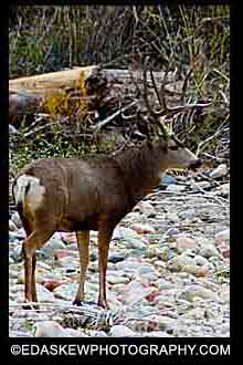
There are many
different wildlife that live within
the park that make great
photographs.
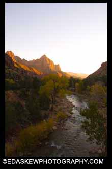
For sunset
photography the famous
location is at the bridge over the
north fork of the Virgin River at
the intersection of Highway 9 and
Zion Canyon Scenic Drive.
This area will be crowded so get
there early.
Home |
About Us |
Contact Us |
Visitor Agreement |
Advertise |
Privacy |
Store |
Newsletter
|